 General Information
Formal Name
The Islamic Republic of Iran (IRIP)
Location
Middle East, bordering the Sea of Oman, the Persian Gulf, and the Caspian Sea, between Iraq and Pakistan
Geographic Coordinates
32 00 N, 53 00 E
Time
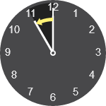
22 Sep 2017 – Daylight Saving Time Ends
When local daylight time is about to reach
Friday, 22 September 2017, 00:00:00 clocks are turned backward 1 hour to
Thursday, 21 September 2017, 23:00:00 local standard time instead.
Sunrise and sunset will be about 1 hour earlier on 22 Sep 2017 than the day before. There will be lighter in the morning.
Also called Fall Back and Winter Time.
Daylight Saving Time in Other Years
DST changes do not necessarily occur on the same date every year.
| Year | DST Start (Clock Forward) | DST End (Clock Backward) |
|---|---|---|
| 2016 | Monday, 21 March, 00:00 | Wednesday, 21 September, 00:00 |
| 2017 | Wednesday, 22 March, 00:00 | Friday, 22 September, 00:00 |
| 2018 | Thursday, 22 March, 00:00 | Saturday, 22 September, 00:00 |
| 2019 | Friday, 22 March, 00:00 | Sunday, 22 September, 00:00 |
| 2020 | Saturday, 21 March, 00:00 | Monday, 21 September, 00:00 |
| All times are local for Tehran. Current year is highlighted. | ||
Area
1.648 Million sq km (slightly larger than Alaska)
Bordering Countries
Afghanistan 936 km, Armenia 35 km, Azerbaijan-proper 432 km, Azerbaijan 179 km, Iraq 1,458 km, Pakistan 909 km, Turkey 499 km, Turkmenistan 992 km, total 5,440 km.
Coastline
2,440 km along the Sea of Oman and the Persian Gulf; Iran also borders the Caspian Sea (740 km)
Climate
Mostly mountain, arid or semi-arid, subtropical along the Caspian Coast
Terrain
Rugged, mountainous rim; high, central basin with deserts, mountains; small, discontinuous plains along both coasts
Elevation Extremes
Caspian Sea -28 m, Mount Damavand 5,671 m
Natural Resources
Petroleum, natural gas, coal, chromium, copper, iron ore, lead, manganese, zinc, sulfur
Land Use
Arable land 10%, permanent crops 1%, permanent pastures 27%, forests and woodland 7%, other 55%
Capital
Tehran
Major Cities
Tehran, Isfahan, Tabriz, Shiraz, Mashad
Population
75,149,669 Dec. 2011 es.
Ethnic Groups
Persian 51%, Azerbaijani 24%, Gilaki and Mazandarani 8%, Kurd 7%, Arab 3%, Lur 2%, Baluch 2%, Turkic 1%, other 2%
Official Language
Persian
Religions
Muslim 99.4%(74,682,938 person) Christians, Jews, Zoroastrians 0.6%
Economy
A mixture of central planning, state ownership of oil and large enterprises, village agriculture, and small-scale private trading and service ventures
Industries
Petroleum, petrochemicals, textiles, construction materials, food processing, metal fabricating, automobile manufacturing
Agricultural Products
Wheat, rice, sugar beets, fruits, pistachios, cotton, dairy products, wool; caviar
Exports
Petroleum, carpets, fruits, nuts, hides, steel
Currency
Iranian Rial
Best Time to Visit
The best time to visit Iran is March-May or September-November. It mostly rains in the winter months and can be very cold and snowy at times. Areas along the coasts enjoy a mild climate.
Transportation
Imam Khomeini international airport is approximately 40 min. ride south of Tehran. Iranians use the internal airlines as their primary means of transportation, located on the verge of town, so flights are often booked well in advance.
Taxis from the airport (and elsewhere) don’t use meters, so be sure to agree on the fare before getting into the cab. There is a reliable prepaid taxi service outside the international arrivals hall.
Shopping
The best places to shop are the bazaars in Tehran, Shiraz and Isfahan. Shop for silks, Persian rugs, brassware, embroidery, ceramics, hand blown glass, antiques, turquoise, carved or painted miniatures, caviar, inlaid wood, enamel work, silver and gold ware and other local handicrafts.
Click here to download Iran Map
en.tehran.ir |
